°Arcus°
Home » Horizons » Magnetic north: tales of whirlpools, giants, temperate seas and a huge lodestone
MAGNETIC NORTH: TALES OF WHIRLPOOLS, GIANTS, TEMPERATE SEAS AND A HUGE LODESTONE
INTO THE MAELSTROM...
Clearly, tales of a vast, treacherous whirlpool somewhere in the region of the northern coastlands of Europe have a factual basis. Indeed, the world's three greatest vortices can be found here: the Saltstraumen strait at Bodø and the infamous Moskstraumen in the Lofoten archipelago, the latter appearing in works by Edgar Allan Poe and Jules Verne, both lie in wait for unwary travellers along the Norwegian coast, while the Corryvreckan (Coire Bhreacain) is a peril lying between Scotland and Ireland. Meanwhile, those those intrepid Norse voyagers who tracked the North American coast just might have gotten wind of the Old Sow, lying off Deer Island and Moose Island at the point of collision between Passamaquoddy Bay and the Bay of Fundy.
The rather evocative term used to describe such phenomena is maelstrom, derived rather suitably from the Norwegian malstrøm, which is composed of two words Dutch origin words: stroom, cognate with the English term "stream"; and the verb malen, meaning "to grind," and sharing a root with the English "mill" - a comparison which may become clearer as we proceed.
DEADLY, DIVINE CHARYBDIS
The vortex of Corryvreckan may appear in the work of Adomnán of Iona, whose famous Vita Columbae features a certain Charybdis Brecani as menacing sailors in the vicinity of an island named Rechru [1.5]. While this Rechru is to be identified with Rathlin Island off the Irish coast, where an overfalls bearing the name of Slough-na-more can be found, the similarity of the two names suggests a connection. Perhaps the name was translated to the current location in the wake of the settlement of the Scottish lands of Dál Riada. It is also well worth noting that, though ignored in the standard Latin version, vast vortices appear in the seagoing descriptions of St. Brendan's travels from the Irish material.
But that is not of primary interest here. More foreboding is the use of the descriptive Classical term Charybdis to describe the phenomenon. Charybdis also appears in the work Paulus Warnfredi, a.k.a. Paulus Diaconus, who, having described the location of the Scritobini, likely the Sámi of northern Scandinavia [1.5], cites Virgil and notes that the term can be applied to whirlpools [1.6]: -
He continues: -
Paulus' "navel of the sea" is likely the Moskstraumen, which we braved previously, and which lies off the western coast of Nordland, in part of Norwegian Sápmi.
About the original Charybdis, Homer has this to say: -
Charybdis' vast elemental powers also feature in a fable of Aesop, which Aristotle mentions in order to dismiss: -
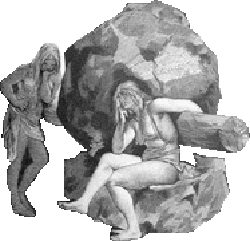
Charybdis' companion is the fearsome and monstrous Scylla, who dwells on the cliff opposite Charybdis, which is so high that its "sharp peak towers to the wide heavens" [Odyssey 12.73-74]. Vast rockfaces in the vicinity of terrifying whirlpools will feature later on in our journey. But for now, we remain with Odysseus on his travels, braving Charybdis once again before we come to the "navel of the sea."
Interestingly, Plutarch places Ogygia west of Britain, close to the confined Cronus, whose name is often applied in Classical sources to the northern seas. Psst... I've got more to about this mysterious land, and its ruler Calypso, but not here.
To end this section, we press on with the Norwegian king Haraldr harðráði's intrepid mariners towards the north, to discover the ends of the sea. There's a narrow escape from the abyss: -
This notion of a "failing world" is most interesting, and brings to mind a much earlier explorer's report of a region seemingly in a perennial process of formation (James S. Romm flirts with such an idea before discounting it). It is to this fellow that we now turn our course.
PYTHEAS AND HIS "SEA LUNG"
Pytheas was a Greek who hailed from the colony city of Massalia, modern Marseilles, who, as a young man in about 325 BC, made the perilous voyage from his home city, perhaps via Burdigala (Bordeaux), to invesigate the mysterious land of Bretannikē, which lay off the north-western coast of Europe. Bretannikē is, of course, modern Britain (whose modern inhabitants includes yours truly), and was known, however dimly, to the Mediterraneans for a couple of centuries by that point, having first been noted by Himilco the Carthaginian, who visited the neighbouring Hierni of the "Holy Island" of Ireland.
Pytheas' mission may have been to secure preferred access to and contacts with the British tin trade, which was of interest to the explorer, who details mining and smelting in what is now Cornwall and transport to the island of Ictis (possibly St. Michael's Mount). However, his efforts extended much further than this, and included a circumnavigation of Bretannikē and a further exploration of the seas to the north of it: he would be the first Classical luminary to give notice of the presence of an even more mysterious land, Thoulē, to the north of Bretannikē, as well as "the frozen ocean, called by some the Cronian Sea" a day's sail from there.
In addition to Pliny (quoted in the last sentence), Strabo adds some more details from Pytheas' account, if only to ridicule it for its implausibility (if only he knew...). This passage contains some intriguing details: -
We leave Pytheas to head back home, with a detour via the Baltic Sea (the trade in amber would have been another interest for the great and the good of 4th century BC Massalia) to the mouth of the Mentonomon (Vistula) and the island of Abalus. We still have business in Thoulē, in particular with a miller whose grindstone is located in the very benthic depths of the great abyss.
THE COSMIC MILL
At the time during which the LORD assumed the weakness of the flesh, when Augustus instituted the Pax Romana, the Danes were coalescing in their isles as a nation under the rule of Skjöldr and his descendants, holding sway at Lejre on Zealand. One of their earliest kings was one Fróði, who oversaw a period of Augustan peace in Northern Europe which for ever afterwards would bear his name, the Fróðafrið. For thirty years would Fróði's Peace hold, an idyllic age which was magnified by the comparison of the tragic, blood-stained times of war to come.
Among his other accomplishments, Fróði enjoyed good relations with his neighbours, including the Swedes to the east, who, like the Danes, were developing into a kingdom, in their case centred upon the storied fane of Uppsala.
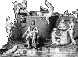
Of course, the history of the Danes and Swedes are oft intertwined and nigh always complicated, and even in this early period, things were no different. Fróði's contemporary was Fjǫlnir, who would later meet his end in a vat of mead during a return visit. From Fjǫlnir, Fróði was keen to purchase a pair of íviðjur named Fenja and Menja, who he planned to put to work in a mill he was in the process of building back in Denmark.
This was to be no ordinary mill: the millstones, a gift from a mysterious fellow by the name of Hengikjöptr, were rumoured to be able to produce anything the owner wished. The name of the mill was Grótti, and no man, not even the strongest of the Danish warrior host, could move it an inch. That would be where Fenja and Menja would come in handy.
Fjǫlnir, probably glad to be rid of a couple of potentially-troublesome gýgjar, agreed to the purchase, and soon Fenja and Menja were busied grinding gold, peace and happiness for Fróði.
Unfortunately, gold, peace and happiness may be good for most people, but when they are ground out at the expense of workers' rights, things can go a little awry, as Fróði soon discovered: the disgruntled giantesses, forced to work in abject conditions unceasingly, began uttering prophecies of doom for the Danes, in the form of the Grottasöngr. Eventually, Fenja and Menja liberate themselves from service by producing an armada led by Mýsingr the sækonungr, who took them and Grótti, asking them to grind salt. The ships sank and a maelstrom or whirlpool emerged as the sea rushed through the centre of the millstone.
Thus, was the sea made salty, during the reign of Caesar Augustus, when the LORD walked among His people Israel.
Of course, giants and giant-kin apppear to be quite important in the legends surrounding the mill. It ought to be recalled that their immediate progenitor Bergelmir the son of Þrúðgelmir, a grandson of Aurgelmir, a.k.a. Ymir, survived the deluge resulting from his slain grandfather's bleeding out aboard a lúðr with his wife. A lúðr can be interpreted as part of a mill. The family of Skjöldr shared a similar origin. Furthermore, Friðfróði contemporary Fjǫlnir was the son of none other than the god Freyr and his giantess bride Gerðr!
Old English sources mention Skjöldr as Scyld or his father Scēafa coming ashore from a northern sea by boat. Scēafa, regarded as a Langobard ruler in Widsið, is said by the chronicler Æthelweard to have alighted on an island on a boat: -
Meanwhile, the great poem Bēowulf states of Scyld: "[p]uny and frail he was found on the shore," aboard the ship īsig ("icy," rather obviously), and was given parallel funeral rites: -
Nigh on a thousand years hence, a certain Snæbjörn, perhaps the same who first cast eyes on Greenland, sang the following stanza, which associates the mill Grótti with another ancient prince, this time the Jute Amlóði, who is better known as the archetype for William Shakespeare's Hamlet: -
Who, you may ask, might these "nine brides of the skerries" be? Well, the most obvious candidates are the nine daughters of wealthy Ægir (who, in his guise of Hlér, may lend his name to Lejre, and may be the Gymir who fathered Gerðr) and his fearsome spouse Rán, namely: Blóðughadda; Bylgja; Drǫfn/Bára; Dúfa; Hefring; Himinglæva; Hrǫnn; Kólga; and Uðr/Unn. It is also worth noting that Ægir has his grain associations, being the brewer of the most widely-known ale in the north. Nine maidens of surpassing beauty also feature in Irish place-lore: -
The significance of this passage is perhaps most keenly felt in the fact that the trip Rúad makes is to Lochlann, which was used as a name for Norway in Irish sources (among other things). Other Irish echoes of this northern mill may be found in that species of Irish tale known as the immrama. The Eóganachta hero Máel Dúin encounters a miller on the mysterious island of Inber Tre-Cenand, where all that is begrudged is ground, while the nature of the mill is even clearer in the tale of the Uí Corra: they meet the "big, surly [?], rough, jet-black, tanned, hideous" Miller of Hell.
THE LIVER SEA
An intrepid German traveller, the eponymous hero of the Herzog Ernst, in his peregrinations comes to a marvellous and perilous stretch of sea. I defer to Malcolm Letts, who contributed an article in Notes & Queries dated to the 10th August 1946 on the subject: -
While the immediate context - i.e. the Euxine or Black Sea - may suggest a region in the near Orient, the presence of the Magnetic Mountain within this Lebermeer or "Liver Sea" point rather more to the extreme north. The "high mountain" echoes Scylla's abode from the Odyssey, and other classical accounts may lie behind other elements in the tale, most notably the griffins. The archaic Greek traveller and proto-shaman Aristeas of Proconnesus, for example, wrote in his Arimaspeia the following account, as paraphrased by Herodotus [4.13.1]: -
These Hyperboreans are obviously a northern people, dwelling as they do beyong the blasts of Boreas, identified as the north wind blowing chill weather from the direction of Thrace. The Hyperboreans came to be widely-famed in Greek lore, but that's a tale for another time.
Letts proceeds to give an etymology for the Liver Sea, in that "the water was 'livered' or thick so as to impede navigation," which immediately reminds one of the "sea-lung" described in the far north by Pytheas.
Similar marine perils appear in a number of other works featured on the site, such as the travels (and travails) of St. Amaro in the Mar Quajado and La Mer Dégringolade in the tale of the Welshman Madoc ap Owain Gwynedd, whose proximity to the "Magnetic Mountain" is signalled by Madoc's having to use antler in place of iron in the building of his vessel. St. Brendan also comes upon the Lebermeer in Dutch and German versions of his story.
GHIMMENDEGOP!
The Libersee also features in an account of an expedition to the north which was written up by Adam of Bremen. This account concerns a number of Frisian noblemen who set out from the Wirraha (Weser) to test the hypothesis that a direct northward journey from there would meet with no land, only that particular stretch of claggy ocean. They do in fact find land, after a fashion - and far more than they bargained for: having passed the Orkneys and spent some time on Iceland, they set off northwards again: -
This abyss is named Ghimmendegop, i.e. Ginnungagap, in a 15th century scholion on this verse. Anyhow, our intrepid heroes (some of them, at least) manage to make their way out of this mortal peril: -
An expression in the Frisians' sister tongue of English is "out of the frying pan, into the fire." Were we not at sea in the frozen northlands at this precise juncture, that would be appropriate. As it is, it almost sounds alluring. But our Frisians had terrors aplenty before they could turn their prows back towards their low-lying lands: -
"But, Graham," I hear you ask: "surely treasure aplenty is a good thing, right?"
Maybe, dear reader, but, I pray, read on. Things are never too good to be true in tales such as this: -
After this decidedly Homeric turn of events, the remainder of the expedition manage to find their way home, suitably chastened, desperate to impart their knowledge to Alebrand, Archbishop of Bremen, and likely also keen to change any soiled breeches or hose. These savage giants would find their way onto the medieval map and consciousness as inhabitants of Riseland, and were perhaps also encountered by Irishmen such as St. Brendan and Máel Dúin. Their fame reached as far as Sicily and the lands of the Arabs: Muḥammad al-Idrīsī writes of the island variously known as Sahalia, as-Shasland or R.slānda: -
When the English developed designs on the New World, inevitably King Arthur got involved, also encountering enormous fellows on the island of Grocland: -
In a striking example of parallelism, Arthur's forces also met with a race of much smaller people: -
This "beautiful open land" is still sought by the more quixotic members of the human community to this very day, on the authority of no less a man than Admiral Richard E. Byrd!
A FORTUNATE DISCOVERY
The account of King Arthur's expedition in the far north is found in correspondence between the famed mapmaker Gerhard Mercator and the Welsh polymath Sir John Dee, written during 1577. It continues: -
These "indrawing seas" would go on to feature in a mysterious, almost legendary, account of travels in this region, namely the Inventio Fortunata, ascribed to English Minorite in around AD 1360 and known primarily during Mercator and Dee's day through the work of Jacobus Cnoyen, a Brabantian, who paraphrased - and likely misconstrued - the Inventio in his Itinerarium. Even the "English Minorite" is an enigma, beyond being based in Oxford and of the Franciscan order, in the service of Edward III. He may not even been an Englishman at all, rather a man of Ireland named Hugh. Richard Hakluyt's suggestion that he was Nicholas of Lynn is likely mistaken, as Nicholas was but a boy when the alleged voyage took place.
Anyhow, I digress. Mercator proceeds with something of an epitome of the Inventio, beginning thus: -
This tantalising section is, sadly, lacunose. Thereafter, Mercator continues: -
This wooded peninsula is presumably a part of "North Norway," also known as Dusky Norway, which: -
The precise location of "North Norway" in a region further west than Norway proper may be hinted at in the nature of the inhabitants: -
This land, of long-forgotten carcasses of ships, signs of abandoned habitations and small people, seems eerily similar to what one may have expected to find in Greenland during the middle of the 14th century. However, the references to the "Grand Cham's land" would suggest otherwise. Further west, there are more of these "indrawing seas": -
One is reminded of the tales of the Moskstraumen and similar phenomena, which brings us to a contemporary description by Ivar Bardsson, writing of his travels to Greenland in 1364, who states the following: -
Back to Mercator's missive: -
Such descriptions are reminiscent of the Norse remarks on Markland, and doubtless led to the conceit that there was an open sea around the North Pole with a surprisingly temperate clime. Now, however, (and after another lacuna), we come to the ultimate end of the Indrawing Seas: -
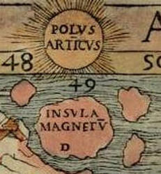
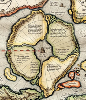
This mighty magnetic island is the Rupes Nigra of the mapmakers and the northern iteration of the magnetic mountain. Now all that remains is to consider the statements of Mercator and his predecessor Johann Ruysch on their maps of the north. Ruysch fusnishes us with the following remarks: -
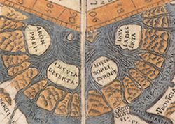
He also provides names for the four islands encircling the Rupes Nigra: -
With regards to Aronphei, Taylor notes the presence of a "Fei Arumfeie alias Cibes," a pair of semicircular islands around a central straight channel which, from the remainder of the Latin legend, appear to correspond to the Island of Demons off the Canadian coast, itself a likely revivification of Satanazes, Antillia's northern companion. Aronphei itself, according to Taylor, corresponds to Mercator's island of the pygmies who bear a resemblance to the Scraelings of Greenland. Their origins may ultimately lie in the conflation of the Arimaspoi, enemies of the griffins living opposite the Hyperboreans, with the Argippeans of Scythia, described by Herodotus as follows [4.23.2-5]: -
Latin writers appear to have begun this conflation, with Pliny the Elder locating the Arimphæi, "a race not much unlike the Hyperborei," who extend to the Riphæan Mountains, in which dwell the griffins of Aristeas [6.7, 14], while Pomponius Mela places them, apparently, north of the Caucasus [1.13].
Mercator, for his part, describes the northern lands as follows: -
The "the best and healthiest" island, in combination with the ancient tale of the Hyperboreans, doubtless led to the notion of the open polar sea, which we will shortly discuss. But first, a brief detour or two.
Momentarily, we trace our steps back to the remarkably-green turf or Ireland, home in days gone by of the remarkable Tuatha Dé Danann and their cloud ships. Before reclaiming their ancestral homeland from their relatives and foes the Fir Bolg, they spent time learning their craft from great and wise teachers in the aforementioned northern islands, whose cities are given the following names and descriptions: -
One further remarkable tale of the northern lands may be found in the Icelandic þáttr af Halli geit. This describes the exploits of a nomadic, tiny, (relatively-)modern-day Ýmir surviving amidst frozen wastes by no more sustenance than the milk of an animal, in this instance a goat. Mountains and forests appear in the story of intrepid Halli: -
Halli had, apparently, set off from Greenland! This tale is tentatively cited by that magnificent latter-day Halli, Fridtjof Nansen, as evidence for the belief in an eastern extension of Greenland as far, perhaps, as the "Farther Bjarmaland" of Novaya Zemlya, while J.R. Enterline (cited above) supposes a possible westward course, which would be an amazing feat indeed.
THE OPEN POLAR SEA
No less an explorer than Christopher Columbus was apparently keen to get his hands on a copy of the Inventio. An avid reader, Columbus' notions of the Atlantic, and subsequently his interpretation of his discoveries, was dependent on medieval literature such as the account of Marco Polo, of which he owned and keenly annotated a copy. One subject which was of interest to "The Most Magnificent And Most Worthy Lord - The Lord Grand Admiral" was the far north. That he tried and (so far as we can tell) failed to secure a copy of the Inventio is apparent from a letter written by John Day around the turn of the year 1498, whose failure to provide Columbus with it led to a profuse apology. Some time earlier, perhaps in 1477, Columbus made the journey to what is presumably Iceland. A letter, epitomised by his son Ferdinand, contains some interesting notices, which read as follows: -
Aside from the mention of the name Frislanda, made famous (or, perhaps more appropriately, notorious) by Nicolò Zen's 1558 map and description of the north, the most important notices are Columbus' knowledge of Ptolemy, as well as his interest in the tides - not to mention the far west. It is also striking that "the sea was not frozen" in February, the height of winter, and this fact may have increased speculation about a temperate area with an open sea further to the north than the icy Libersee and its frosty ilk.
Though Columbus, if he ever intended such a venture, never followed through with a voyage towards the North Pole, the idea had gained new life by 1527, when the Englishman Robert Thorne, then based in Seville, pondered upon the possibility of his country's seeking to exploit northern routes to the Spice Islands, suggesting that these would be quicker and safer than the new Portuguese route around Africa. Sadly, this never got past the "pipe dream" phase of development: England was, at that time, under the backwards-looking rule of Henry VIII, whose failure to follow up on his father's commissioning of John Cabot's explorations was exacerbated by religious turmoil following the failure of his marriage to his Spanish queen within a few years. Thorne, though, can claim to be the intellectual father of the later English - and, subsequently, Dutch - endeavours to find routes in the north, initially to Muscovy and beyond.
Around 1652, another Englishman, Joseph Moxon, was in Amsterdam, pursuing his interest in cartography and mathematics. He fell in with an old salt in an alehouse, a Dutch native with experience of the Spitsbergen (which the English of that time insisted on calling Greenland, another hold-out from the Halli geit days) whaling grounds, and was party to a conversation between this fellow and another mariner, who told him a likely tale. Reminiscing some twenty-two years later, Moxon, now Hydrographer to the restored monarch Charles II, recorded the following: -
An astonished Moxon has to know more, and interrogates the recently-returned sea-dog: -
Moxon, somewhat apologetically, explains the reasons why his account is a little light on detail: -
No design indeed: we must bear in mind that, during 1652, the First Anglo-Dutch War was in the process of breaking out. However, Moxon is a decent authority, gaining the respect of Charles II despite his earlier Puritan leanings, so I for one am willing to take him at his word.
Another who did likewise was one Captain John Wood, who set out for the Pole in 1676 to seek a passage to the east of Spitsbergen. He was, needless to say, stymied by walls of ice. This prompted him to withdraw the benefit of the doubt from Moxon and his peers, accusing reporters of an open sea of wilfully misleading navigators and their funders, their expensive and dangerous ventures being little but fools' errands.
A century later and the chattering classes of Georgian England (our homeland being a world leader in somewhat offbeat and inevitably erroneous ideas) were dropping their Ming teacups when the fantastically-named Hon. Daines Barrington furnished the esteemed Royal Society with his case for an Open Polar Sea. One corollary from this was the Phipps expedition to the north, which included a certain Horatio Nelson on the crew as midshipman. This fifteen-year-old adventure-hungry lad allegedly distinguished himself by picking a fight with a polar bear! Nicknamed Na-polarbear Bonaparte! Seriously!
Well, that's what an old sailor once told me during a drinking session in Amsterdam around the turn of the millennium.....
Last of all, we consider two great explorers who have already been mentioned in dispatches. Firstly, Fridtjof Nansen, whose expedition aboard the Fram saw his crew deliberately cast themselves to the mercy of the ice for three years is regarded by the eloquent John K. Wright as having dealt the Open Polar Sea theory its final doom: "The theory of an Open Polar Sea [...] was already mortally striken before 1880: Nansen gave it the coup de grâce."
Secondly, that great American hero Richard E. Byrd, around whom so much mythology associated with both poles circulates like bees about a flower (or, perhaps, wrecked hulks around the Rupes Nigra), whose exploits have given a new impetus for those who propound bizarre theories about a temperate Arctic region leading inevitably into the Inner Earth. Byrd's supposed diary for February and March 1947 contains a flight log which gives credence to the notion that we live on the shell of a hollow planet, as well as a source for the "UFO" phenomenon: -
Just when things seem as though they could not get any weirder, they take a turn towards the decidedly more weird, replete with more superflous exclamation marks aplenty: -
The diary entry continues with a rather lurid tale of an advanced civilisation of German speakers living within the hollow pole. They are led by a shadowy figure known as the Master, who welcomes Byrd to "the domain of the Arianni, the Inner World of the Earth." Byrd is sent back with a message, which he duly delivers to the higher echelons of the US military and President Harry S. Truman, only to be "ordered to remain silent," predictably enough.
While the Hollow Earth is a story which is best placed elsewhere, suffice to say that the mysterious realm of Agartha or Asgartha, said to derive from ancient Indian records, is patently nothing more than a cipher for the Norse Ásgarðr, its advanced inhabitants none other than the Norse gods cosplaying as nabobs, East India Companymen.
