ANTILLIA: A PHANTOM ISLAND IN THE ATLANTIC
INSULAE DE NOVO REPERTE: CARTOGRAPHY
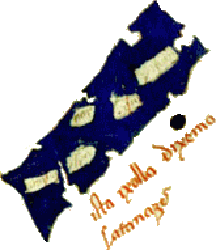
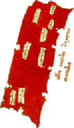
Antillia normally forms part of a four island archipelago on maps of the 15th century, with it and another, generally termed Satanazes being the largest, and rectangular in configuration. Both have smaller companions, in Antillia's case Royllo (though Zuane Pizzigano, the earliest of the cartographers, renders the name as Ymana). The following table lists the cartographers, the dates of their works and the names of the islands contained therein: -
The abrupt change in the name of the northern island from the Satanazes type to Saluagia and the like from the 1460s onwards can perhaps be explained by Diogo Gomes de Sintra's 1438 discovery of the desolate Salvage Islands.
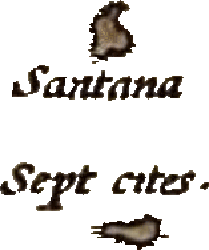
THE SEVEN CITIES: CARTOGRAPHY
Antillia is linked in myth with seven cities founded by Visigothic bishops fleeing the Moors in the early 8th century. In addition to these are more settlements on Satanazes. A number of the maps mentioned above provide names for these polities: -
| Antillia | Satanazes | ||||||||||||
|---|---|---|---|---|---|---|---|---|---|---|---|---|---|
| Zuane Pizzigano | 1424 | Asay | Ary(?) | Vra | Jaysos | Marnlio | Ansuly | Cyodue(?) | Nar | Ymana(?) | Con(?) | Ysya | Aralia |
| Grazioso Benincasa | 1463 | Antuab | Ansesellj | Ansollj | Con | Ansodi | Ansollj | Aira | Jmada | Cansilla | Nam | Araialis | |
| Grazioso Benincasa | 1470 | Antuub | Ansessellj | Ansollj | Con | Ansodj | Ansollj | Aira | Duchal | Jmada | Cansilla | Nam | Araliais |
| Andrea Benincasa | 1476 | Asal | Ensa | Ena | Cone | Ansors | |||||||
| Albino Cánepa | 1480 | Asal | Cusa | Cua | Marolio | Ansodi | Anso | Hare(?) | Viuadi | Ten | Nar | Ysua | |
| Grazioso Benincasa | 1482 | Antinib | Anselseli | Ansolli | Con | Ansodi | Ansalli | Aira | Duchal | Jmada | Consilla | Nam(?) | Aralias |
| Grazioso Benincasa(?) | c.1482 | Con(?) | Ansodj(?) | Ansollj(?) | Jmada | Cansilla | Nam(?) | ||||||
| Albino Cánepa | 1489 | Asal | Cusa | Cua | Marolio | Ansros | Ansoa | Choue(?) | Viuadi | Tem | Nar | Isua | |
The names Con, Consilla and Cansilla, which appear as the names of towns on both islands, are associated by Armando Cortesão with the Irish tale of the hero Connla mac Conn and his fairy maiden love, in which Connla embarks in a curragh which is seen to "glide away over the bright sea towards the setting sun." Connla and his bride, now given the name Venusia, is later met by the Munsterman Teigue mac Cein in a land called Inis Derglocha.
THE MYTH: A VISIGOTHIC REFUGIUM
After being ousted from Gaul by the rising power of the Franks, the Visigoths developed an advanced post-Roman culture of their own in Iberia, which survived into the eighth century AD before its destruction by the invading Arab-Berber armies of the Umayyad Caliphate. The embattled king Rodrigo, turning away through necessity from internal enemies to face this new and powerful foe, fell at the battle of the Guadalquivir in AD 711 and soon all but a stubborn holdout in the mountain fastnesses of Asturias was under caliphal control. It is in the aftermath of this invasion that our legend begins.
The most common version of the tale takes place in about AD 714 and features a group of seven bishops, led by the Bishop of Porto, who set out on an intrepid voyage into the far reaches of the Atlantic in search of refuge. They eventually discover a fine island where they agree to settle, poignantly burning their ships to prevent any thoughts of further flight and found seven cities, one for each of their number.
Martin Behaim, whose globe provides details found above, gives us the following account, which he dates a couple of decades after the conquest: -
Johannes Ruysch, on his map of 1507/8, furnishes a similar description, which alludes to the supposed 15th century rediscovery of the island: -
Ruysch's description is followed by Pedro de Medina, who, in 1548, added a number of other enigmatic details, claiming that Antillia was 87 leagues in length and 28 in width, and boasting good harbours and rivers. Interestingly, instead of crediting Ruysch, Medina claims that his source was an antique map produced by one "Tolomeo" at the behest of "Papa Urbano," suggesting a chart based on the work of Claudius Ptolemaeus produced in the pontificate of Urban VI (1378-1389). This would be a decade after the chart of Domenico and Francesco Pizzigano (1367), who state that navigation is impossible beyond a point interpreted as "statues on the shores of Atullia," which is most likely a reference to the pillars of Heracles. The details of the burning of the ships and the 714 date originate with Ferdinand Columbus, writing in 1539.
A further detail appears in the work of Manuel de Faria e Sousa, writing in about AD 1628. He mentions Sacaru, governor of Mérida, who negociated a withdrawal from the mainland to lift a Moorish siege. He gathered his followers and set out for the Canary Islands, though Faria e Sousa speculates that he may have ended up on Antillia, which is described as an island "populated by Portuguese" with "seven cities." Faria e Sousa adds that this island was believed to be visible from Madeira.
THE SEVEN CITIES: DISCOVERY
Thus reports Thomas Wentworth Higginson in his Tales of the Enchanted Islands of the Atlantic with regards to Antillia. This pair had supposedly come from Antillia, though the tale also appears eerily reminiscent of the aforementioned adventure of Connla mac Conn.
The next notice we have appears on Behaim's globe, which states that: -
Actual footfall on Antillia would have to wait until the Portuguese Age of Discovery. The famous Henry the Navigator was the impetus for this remarkable period of history in many ways, and dealings with the islanders during his time (the 1430s and 1440s) were reported by Ferdinand Columbus. António Galvão, writing in 1563, records an account of Portuguese mariners travelling to Antillia. An Early Modern English translation renders the following: -
This likely led to a new-found confidence in the reality of this Island of the Seven Cities, for the Portuguese kings Afonso V and João II mention them in letters concerning one Fernão Teles and a Fleming, Fernão Dulmo. Teles is granted "the Seven Cities and any other populated islands" he chanced upon in the Atlantic as his fief in 1475, while Dulmo was authorised to search for the island in a royal letter of the 24th July 1486. In a similar vein, the Infanta D. Brites was given a grant in 1473 of "an island, that appeared beyond the island of Santiago."
Furthermore, the concept survived the discovery of the Americas into the 17th century: William H. Koebel, in his Madeira Old and New, tells us a rather fanciful account of a group of friars coming upon a mysterious Atlantic island: -
The friars are given three days' leave by the captain to explore: -
ANTILLIA AND SAHALIA
The great Arab geographer Muḥammad al-Idrīsī describes an island named Ash-Shasland (Sahalia in Latin), which is large and formerly inhabited: -
Whilst Sahalia has sometimes been compared to Antillia, it is unlikely to be a match. Interestingly, though, al-Idrīsī states that he will have more to say when discussing Ireland about this matter. The most likely explanation is an island inhabited by Norsemen, rather than Iberians.
ANTILLIA AND AL-MUSHTASHKIN
Perhaps a more likely candidate is the island of al-Mushtashkin or al-Tinnin, the latter of which was posited as etymologically-similar to Antillia by Alexander von Humboldt. This island was home to a population freed by Alexander the Great from the depradations of a dragon.
A DISAPPEARING ISLAND?
The aforementioned Manuel de Faria e Sousa, concluding his description of Sacaru's flight into the Atlantic, mentions the following, about Antillia: -
This is quite the common trope, what with mirages and illusions being a fact of science. But disappearing Atlantic islands, unable to be reached, are a figure of many mythologies. Particularly pertinent are Arabic sources, with the Akhbār al-zamān mentioning floating and vanishing islands in the region: -
On the latter occasion, the text reports that sailors mention a sea fish called a chākil, the carrying of which enables mariners to break the enchantment and land on the island.
ANTILLIA, RICH IN GOLD AND/OR SILVER?
António Galvão's account of the 1447 Portuguese visit to the island gives the following interesting detail: -
Again, the Arabs furnish us with a possible analogue. The Akhbār al-zamān tells us of as-Sayārah, another western island: -
It is prudent at this point to record that the Seven Cities were eventually transferred in the Spanish imagination to what is today the southwestern United States. Silver, too, was allegedly to be found in Antillia. The so-called "Columbus Map," today in Paris, records the following: -
This seems firmly based upon the same information as Galvão's putative source, though it is interesting to note that the Spaniards claim that the "gold" is in fact silver.
SATANAZES: ANTILLIA'S DEVILISH COMPANION?
The name of Antillia's more northerly sister island is given before 1438 variously as Satanazes and Satanagio. Quite possibly this comes benignly from the name of St. Athanasius, which would be strangely apt given his role as the great champion of Christian orthodoxy against the Arian movement which, for so many years, was the major religion of the Visigoths. However, the first five letters spell a far more ominous name, which has led to speculation about this "devil's isle."
Again, Arabic tradition comes to our aid, with tales of the throne of Iblis, chief of the rebels against Allāh: -
An association with the "hand of Satan" rising from the sea is also potentially at play in the name as given on Bianco's 1436 map: De la man satanagio.
This, however, could be a misreading, with the "De la man" instead being the name of Satanazes' smaller counterpart, commonly called Tanmar.
AN AUTHENTIC ISLE AND A LAND OF PARROTS
Under the aegis of that most brilliant father of the European "Age of Discovery," the Portuguese prince commonly known in English as Henry the Navigator, the sailors of that most enterprising nation defeated age-old superstition by making their way beyond the feared Cabo de Não, rediscovered the Macaronesian islands and charted much of the coast of north-western Africa. While posterity makes theirs an unfortunate legacy, marking the beginnings of the gruesome Atlantic trade in human beings which persisted for some four centuries, these intrepid explorers also made possible the European discovery and colonisation of the New World.
We have already had cause to mention the myth that inspired them and an alleged visit to a mysterious land in 1447. But surely that visit, too, was no more than legend? Is there anything in the more sober sources which support such claims?
Actually, there might just be...
In 1445/6, Lançarote de Freitas, a member of the Infante Henry's household, led an armada of some fourteen ships further down the African coast than ever before. Among their firsts were the first colony in the area, at Arguin (which may well have been built atop the Carthaginian trading settlement of Cerne) and the first exploration of the Senegal River, as well as an early, tentative visit to the Cape Verde Islands.
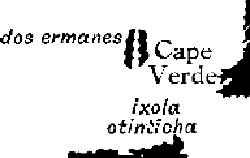
... but there may be more. In 1448, Andrea Bianco, a Venetian cartographer, was in London, busily etching a new map which referenced all of the previous Portuguese discoveries and has a notable focus on Africa. Antillia, which is present on his 1436 map, has gone, replaced by the Azores. However, further to the south, just on the edge of the map we have today, there lies a similarly-lengthy land mass, which is indicated as the ixola otinticha, the "authentic" or "genuine island."
What could this be? A short distance northwards, where we find the Cape Verde archipelago, are the dos ermanes or "two brothers," islands with a significant pedigree in Arabic sea-lore. So, is this another of the same group?
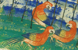
H. Yule Oldham did not think so, preferring an identification with the north-east coast of Brazil, though his ideas are hardly consensus. The detail of the parrots suggests that the quote above is a red herring, as the island described there is most likely the Île de Gorée or Beer Dun, an island off the coast at Dakar.
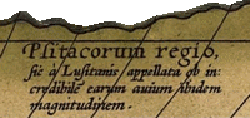
Nevertheless, parrots appear in the context of Portuguese discoveries in the unlikely setting of the unknown southern continent (and also feature on the Cantino planisphere of 1502, two years after the first Europeans are confirmed to have reached Brazil), in the particular region below Africa, in Abraham Ortelius' world map. Ortelius' inscription reads Psitacorum regio sic a Lusitanis appellata ob incredibilem earum auium ibidem magnitudem ("this region is by the Portuguese called 'of the Psitaci' because of the incredible number of birds of the same size). Certainly (bird-)food for thought.
